
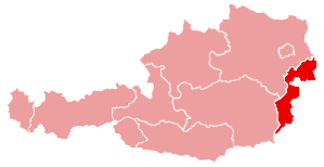
Burgenland is one of the nine states of Austria. Lower Austria borders Lower Austria and Styria to the west, Slovakia to the northeast, Hungary to the east, and Slovenia to the far south. The capital of Burgenland is Eisenstadt. It is 3,966 km2 and has less than 280,000 inhabitants, making it the seventh largest state in size and the smallest in population.
History[]
Burgenland formed the westernmost region of Hungary during the Middle Ages. After the Battle of Lechfeld (955) in which the Magyar army was defeated, Germans began to settle in the area. A 1043 treaty between the Emperor and the King of Hungary fixed the border along the Leitha River. German settling was continuous during the Middle Ages, and immigration increased when Protestant Germans fled to the Burgenland following the religious upheavals of the 16th and 17th Centuries. The Habsburgs occupied the present-day territory of Burgenland after 1440, but the Hungarians recaptured it in 1477. In 1491 it was mortgaged to the Archduke of Austria, which returned it in 1647. During the 17th-18th Centuries the Burgenland was dominated by Roman Catholic landowners, such as the Esterházys and the Batthyánys.
Following the collapse of the Austro-Hungarian Empire after World War I, the inhabitants intended to join the new Republic of Austria. Following a plebiscite in which the majority of the population voted for union with Austria, the Treaties of St. Germain and Trianon fixed the date of unification on 28 August 1921. However the unification was delayed by pro-Hungarian sharpshooters, and it was not until Autumn that the crisis was resolved by a new plebiscite in Sopron and eight other communities. The result was a clear vote for Hungary, and those communities were united with Hungary.
The first elections occurred on 18 July 1922. In 1925 Eisenstadt was selected as the official capital of the state, and the government met in alternating estates until the construction of a landhaus was completed in 1929. The census of 1923 showed a difference in ethnic composition than an earlier one in 1910. The percentage of Germans had increased from 74% to 80%, while the number of Hungarians decreased from 9% to 5% spurred be an exodus of Hungarian intellectuals and civil servants. After the Anschluss united Austria with Nazi Germany in 1933, the state o Burgenland was abolished and the territory was divided between Styria and the new Lower Danube. Roma and Sinti ethnic minorities suffered xenophobia, and a policy of forced Germanisation negatively affected other minorities such as Croats and Hungarians. The Nazis constructed a wall around Burgenland with forced Jewish labourers (which proved useless when Soviet troops invaded in 1945), and in the last days of the Nazi regime it was home to Jewish massacres and death marches.
On 1 October 1945 Burgenland was reestablished and was given to Soviet administration in exchange for Styria (which was given to the United Kingdom). The recovery was very slow due to mistreatment by the Soviet authorities and an anti-investor atmosphere. It was only in 1955 when the Soviets withdrew from administration that the recovery effort began. After the Hungarian Revolution was brutally suppressed by the Russians in 1956, the Burgenland was inundated with Hungarian refugees which were welcomed warmly. The Soviets built a series of walls and minefields on the border with Burgenland called the "Iron Curtain" in 1957, but from 1965 - 1971 the minefields were cleansed. On 27 July 1989 the Austrians and Hungarians cut the Iron Curtain at the village of Klingenbach. Thousands of East Germans would eventually flee to the west through the village. It was only in 2004 that border with Hungary was fully opened.
| States of Austria |
|---|
| Burgenland | Carinthia | Lower Austria | Salzburg | Styria | Tyrol | Upper Austria | Vienna | Vorarlberg |